Where was I?
The addition of enhanced geotagging in Lightroom 4 prompted me into looking at options for recording GPS coordinates using the Nikon D700. The camera provides EXIF data fields to store latitude, longitude, altitude (!) and time. Many smart phones, like the iPhone, already record such data and the capability is increasingly making its way into point-and-shoot cameras as they desperately try to postpone the day when they will be history, trampled into the technological dust by cell phones. However, full frame Nikons, which may be around a while yet, lack this technology, so a separate device has to be used.
I looked at Nikon’s GPS receiver and immediately crossed it off the list. It’s wrong in every way. It fits in the accessory shoe where it’s waiting to be wrenched off, and the camera will no longer fit in my camera bag with the unit mounted. It uses an ungainly cable to plug in to the ten pin socket on the front and it sucks on the camera’s battery for power. Switch the camera off and the unit is switched off, meaning 30+ seconds to reacquire a GPS lock when next switched on. (First data acquisition is typically 30-40 seconds with GPS devices, with changes recorded at 1 second intervals thereafter, as long as the unit remains powered up). Try and use the built-in pop up flash with the unit in the camera’s accessory shoe and you cannot. Finally, it’s silly priced at $195. Canon users can rejoice in the knowledge that if the Nikon’s unit is silly priced, the Canon’s means you are Rockefeller, as its GP-E2 costs $270. In that case, of course, you can afford it. It works on the 5D/II, 5D/III and some of the ‘pro’ bodies whose nomenclature I forget. Doubtless aftermarket solutions exist at sane prices.
The right way to do this is to use a very small Bluetooth receiver which plugs directly into the D700’s (or D800/D3/D4) body, deriving GPS data from a separate GPS data logger. The data logger has its own battery to do the heavy lifting of acquiring coordinates from satellites, transmitting these to the receiver on the camera, the latter using modest amounts of power from the camera’s battery for the Bluetooth circuitry only. The logger can be left on all day, as it has a ten hour life, so the reacquisition problem goes away even if the D700 is turned off, as the GPS logger remains on at all times.
The only snags I can see is that you have to remember to recharge the battery in the GPS logger and that there is no ten-pin pass through port, so if you want to use any other device which needs the port, like a cable release, you are out of luck. However, the receiver does have a mini-coaxial socket for remotes so if I can find the right cable I should be able to use my wireless remote uninterrupted. Well, there is one other snag, but it’s unlikely to bother me. the software which comes with the logger will run on Windows only, displaying your journey details. It’s not a snag as it will be a cold day in hell before I ever use Windows again and and I really do not need to retrace my travels. All that matters to me is knowing where the pictures were taken.
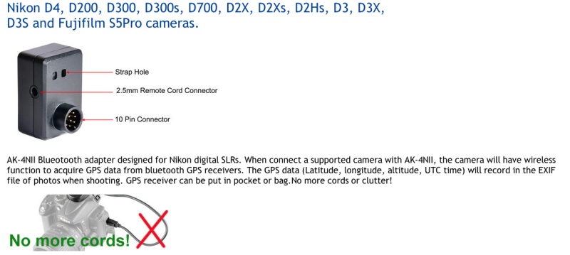
The GPS Bluetooth receiver.
The receiver ran $60 on eBay and as the grammar-free English confirms, it’s shipped from China. The vendor is named “photohobby” and lists the device as “Bluetooth GPS adapter AK-4NII for Nikon D4 D200 D300 D300s D700 D2Xs D3 D3s D3x”.
The GPS device itself looks like this – “photohobby” lists a large range of devices which will work:
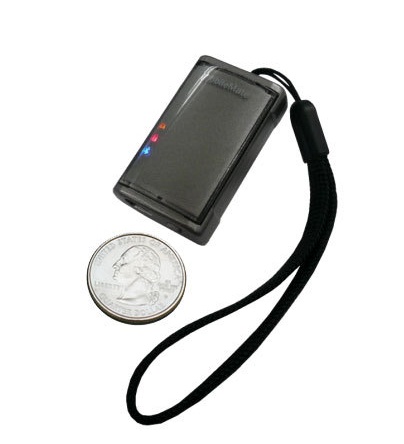
i-Blue MobileMate 886 Mini Bluetooth GPS Receiver.
I chose this one because it was the smallest and lightest out there, yet still promises a 10 hour battery life. You keep it in your pocket or in the camera bag, switched on while snapping. It cost $47 shipped from CA to CA, Amazon and many others carry it, and comes with USB and car charger cables. Weight is negligible.
Thus my total geotagging investment is $106, or almost half the price of the Nikon OEM solution with its poorly thought out design.
Now, I would love to tell you I have upgraded to Lightroom 4 and gush on about how wonderful it is but there are two reasons I cannot do so. First, I’m not some whore who adulates Adobe in print because I make a living from teaching the illiterate how to use their products. Second, Adobe’s servers are down and I cannot download the upgrade. What else is new?
However, the geotagging functions in LR4 seem easy to use and I’m of the mind that soon geotagging data will be expected, rather than just a novelty. Here’s a snap of how photo locations appear in LR4:
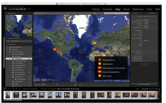
Geotagging in Lightroom 4.
More in Part II when the mail from the People’s Republic arrives. Hopefully, Adobe’s servers will have been fixed by then.
Alternative approaches:
As I seem to be getting a lot of emails on alternative GPS recording methods, all of which I researched before writing the above. Here’s is why I avoided them:
- Use software to extract GPS data from your smartphone or GPS device, then sync it with your photographs, hoping that you remembered to sync the camera’s clock with the one in the GPS source as that’s the lookup field used for matching. Uh huh.
- Hack your iPhone to unlock it using something like Cydia, which permits you to access your iPhone’s GPS data stream and Bluetooth output with like functionality to the i-Blue gadget I bought, above. And you are OK with draining your iPhone’s battery really fast? And you are OK with re-hacking it every time Apple does a software update and disables past hacks? And you don’t care if you can’t make calls when you brick your iPhone and have to restore it?
I guess it all comes down to what your time is worth and whether you prefer futzing about to making pictures.